The global demand for reforestation has never been greater. Governments, corporations and environmental organizations are committing to planting billions of trees as part of climate action plans and carbon offset programs. But planting trees is only half the challenge -- proving that those trees were actually planted, where they were planted and how much area was covered is the other half. Traditional manual tracking methods are failing to meet the accountability standards that modern reforestation programs demand. Reforestation tracking software is emerging as the essential tool for silviculture contractors, government agencies and carbon offset project managers who need accurate, verifiable data from every planting operation.
The growing demand for reforestation accountability
Across North America, reforestation programs are expanding rapidly. Canada has committed to planting two billion trees, provincial governments mandate regeneration on Crown land after harvesting, and the voluntary carbon market is driving unprecedented demand for verified tree planting tracking data. In the United States, federal and state programs are investing heavily in forest restoration across both public and private lands.
This expansion brings with it a growing demand for accountability. Clients paying for reforestation want proof that their money was well spent. Government agencies need documentation that regeneration obligations have been met. Carbon offset buyers require verifiable data showing that trees were planted at the specified density across the claimed acreage. The days of accepting a contractor's handwritten tally sheet as proof of planting are rapidly coming to an end.
The problems with manual tracking
Traditional tree planting tracking relies on manual counts, hand-drawn maps and paper-based daily reports. This approach suffers from several fundamental problems that undermine data quality and operational efficiency.
Inaccurate planting counts
Manual counting of planted trees is inherently imprecise. Planters estimate their daily totals, supervisors spot-check a fraction of the work, and the final numbers often rely on extrapolation rather than measurement. Disputed counts between contractors and clients are common, leading to delayed payments and strained relationships. Without objective data, there is no way to resolve these disputes definitively.
Disputed acreage coverage
Determining exactly how much area has been planted is even more challenging than counting trees. Manual methods rely on visual estimation and rough measurements that can vary significantly from actual coverage. When clients conduct their own verification surveys and find discrepancies with the contractor's reported acreage, the resulting disagreements can be costly and time-consuming to resolve.
Delayed reporting
Paper-based reporting introduces significant delays between when planting occurs and when data reaches the office. Daily tally sheets must be collected from each planter, compiled by the supervisor, transcribed into a spreadsheet and then formatted into client reports. This process can take days or even weeks, leaving clients and project managers without timely visibility into planting progress. When problems are discovered -- such as a planter consistently missing target density -- the delay means that corrective action comes too late.
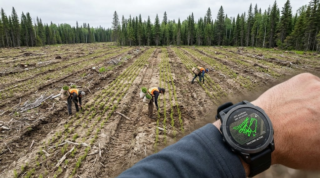
The TrackLogix solution: smartwatch GPS tracking of every planter
TrackLogix fundamentally transforms reforestation tracking by equipping each planter with a GPS-enabled smartwatch that continuously records their movements throughout the workday. This simple but powerful approach generates a precise digital record of every planter's path across the planting block, creating an irrefutable map of where planting actually occurred.
The smartwatch is lightweight, rugged and designed for the demanding physical work of tree planting. Planters simply wear the watch and go about their work normally -- there is no data entry, no button pressing and no disruption to their planting rhythm. The GPS records their track at configurable intervals, building a detailed picture of their coverage pattern throughout the day.
The system uses the GPS track data to automatically calculate the area covered by each planter, the total area covered by the crew and the density of planting coverage within each block. When combined with the known planting specifications (trees per hectare, spacing requirements), TrackLogix generates objective, GPS-verified production data that replaces subjective manual estimates.
Automatic production reports without paperwork
One of the most significant benefits of TrackLogix is the elimination of paper-based reporting. The system automatically generates production reports from the GPS data, calculating key metrics including planted area per planter, total crew coverage, daily and cumulative progress against targets, and estimated tree counts based on coverage area and specified density.
These reports are generated automatically at the end of each day, without any manual data entry or compilation. Supervisors review the data on a dashboard rather than collecting and transcribing paper tally sheets. Client reports can be generated with a few clicks, showing GPS-verified coverage maps alongside production statistics. The time savings compared to manual reporting are dramatic -- what used to take hours of compilation now happens automatically.
Real-time dashboard showing planter positions and progress
The reforestation monitoring dashboard provides supervisors with a live view of their entire planting operation. Each planter's current position is displayed on a map, along with their track for the current day and their progress against daily targets. This real-time visibility allows supervisors to identify problems immediately: a planter who has stopped moving may need help, a planter whose coverage pattern shows gaps may need guidance on spacing, and a planter who is falling behind target can be supported before the end of the day.
The dashboard also provides a bird's-eye view of block coverage, showing which areas have been planted and which remain. This enables supervisors to direct planters to uncovered areas and ensure that the entire block receives complete coverage. For operations running multiple blocks simultaneously, the dashboard provides an overview of progress across all active sites.
Works across Canada and the United States
TrackLogix is designed to work anywhere that silviculture tracking is needed. The system operates across all Canadian provinces and US states, with no dependency on specific cellular networks or regional infrastructure. The smartwatches record GPS data locally and synchronize when connectivity is available, whether via Wi-Fi at a camp, Bluetooth to a supervisor's tablet or cellular network when in range.
This flexibility makes TrackLogix suitable for the full range of North American reforestation contexts, from large-scale boreal planting operations in northern Ontario and Quebec to restoration projects in the forests of New Brunswick, British Columbia or the northeastern United States. The system adapts to different planting methods, block configurations and reporting requirements without custom configuration.
Perfect for silviculture contractors, government programs and carbon offset projects
Silviculture contractors benefit from TrackLogix by gaining objective data that supports their billing, resolves disputes with clients and demonstrates the quality of their work. The GPS-verified coverage maps serve as irrefutable proof of planting, replacing the subjective estimates that have historically led to payment disagreements.
Government agencies that mandate reforestation on Crown land after harvesting can use TrackLogix data to verify that regeneration obligations have been met. The GPS-verified acreage and coverage maps provide the documentation needed for compliance verification without requiring costly field audits.
Carbon offset project managers need verifiable planting data to support their carbon credit claims. TrackLogix provides the GPS-based evidence of planting location, coverage area and planting density that verification bodies require. This data trail supports the credibility and marketability of carbon credits generated by reforestation projects.
The combination of TrackLogix for field tracking with ForestLogix for project management and SyncLogix for data synchronization provides a complete digital ecosystem for reforestation operations of any scale.
See TrackLogix in action -- request a demo
Whether you are a silviculture contractor looking to modernize your planting operations, a government agency seeking better verification of reforestation obligations, or a carbon offset project manager who needs verifiable planting data, TrackLogix delivers the reforestation tracking software solution you need.
Request a demo and see how TrackLogix transforms tree planting tracking with real-time GPS monitoring, automatic production reports and verifiable coverage data. Our team will show you exactly how the system works in the field and how it integrates with your existing operations.